
Geography Intent
Our geography curriculum aims to deepen knowledge and understanding about our local environment and the wider world as well as encouraging the gaining of essential geographical skills and knowledge to be used with a variety of resources. Geography is taught through a variety of well-planned, exciting topics which enables the pupils to feel inspired and fascinated about the world in which they live. Our curriculum aims to consolidate and extend learning attained in KS1.
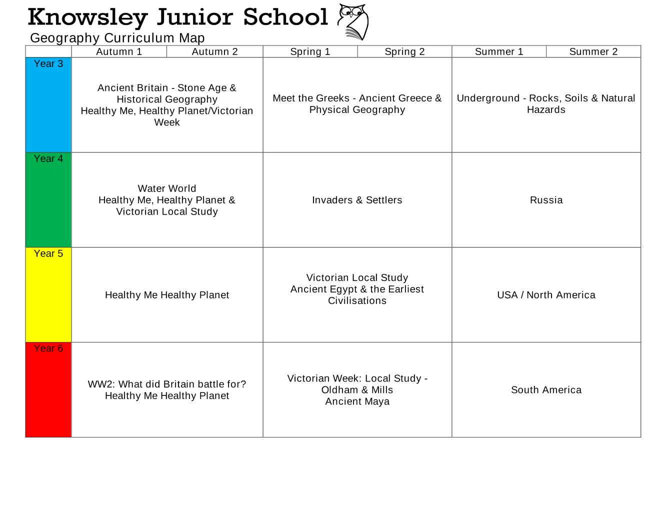
Geography Curriculum Map
Please select from the documents below.
Geographical Golden Thread Overview
Please select the document below.
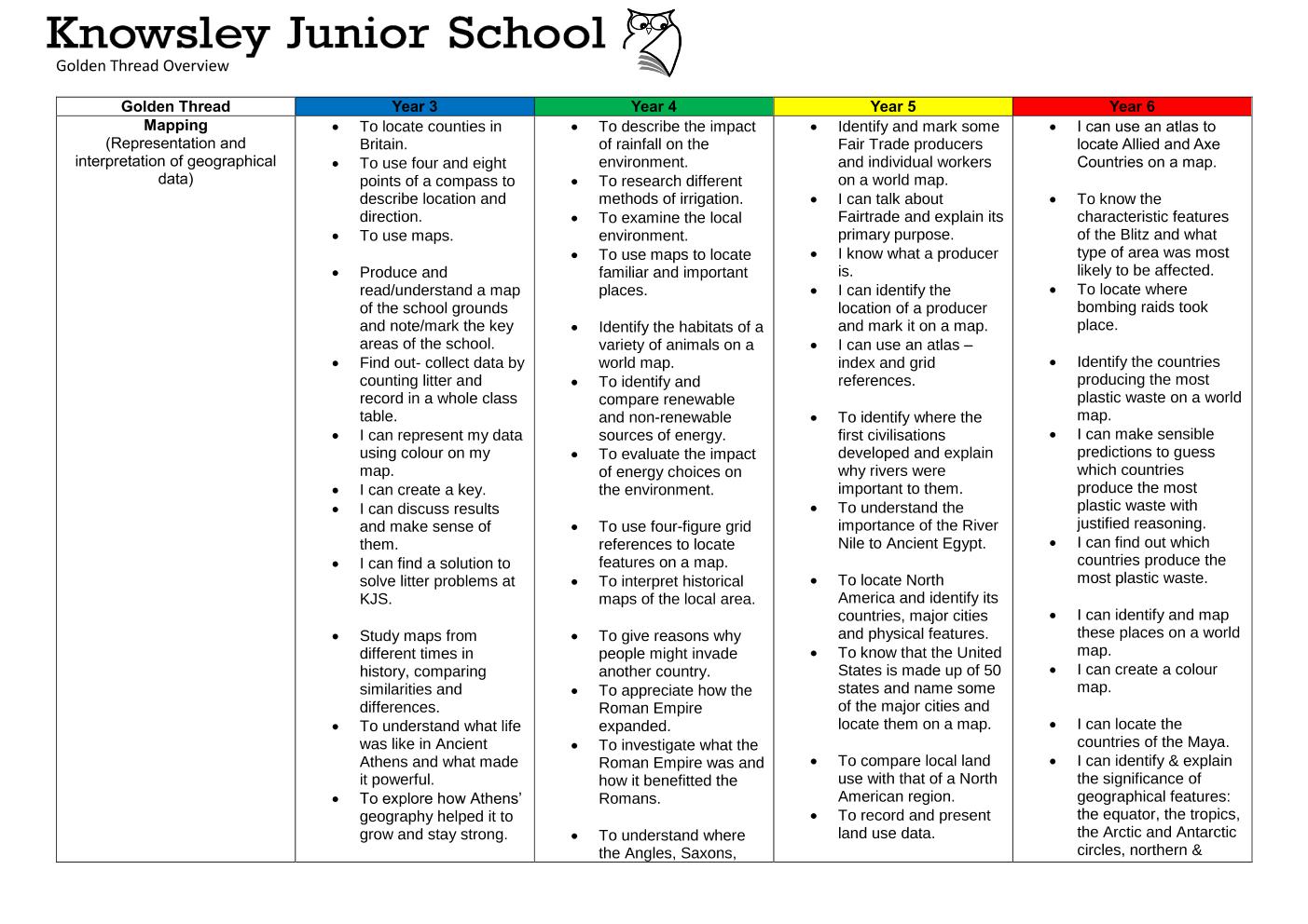
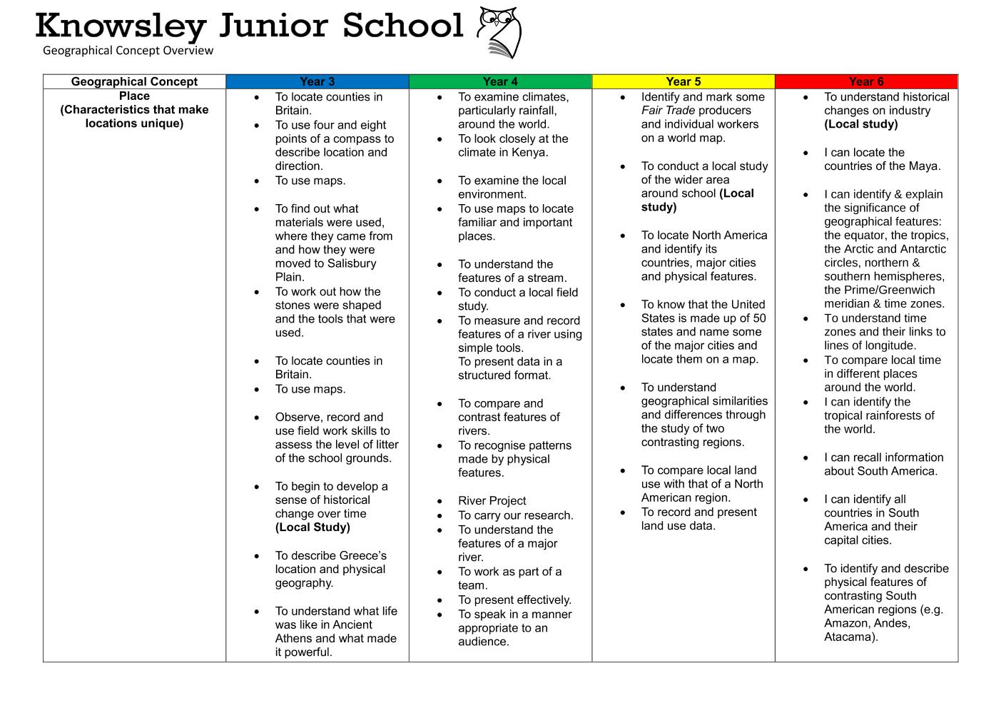
Implementation: Geography Skills and Knowledge
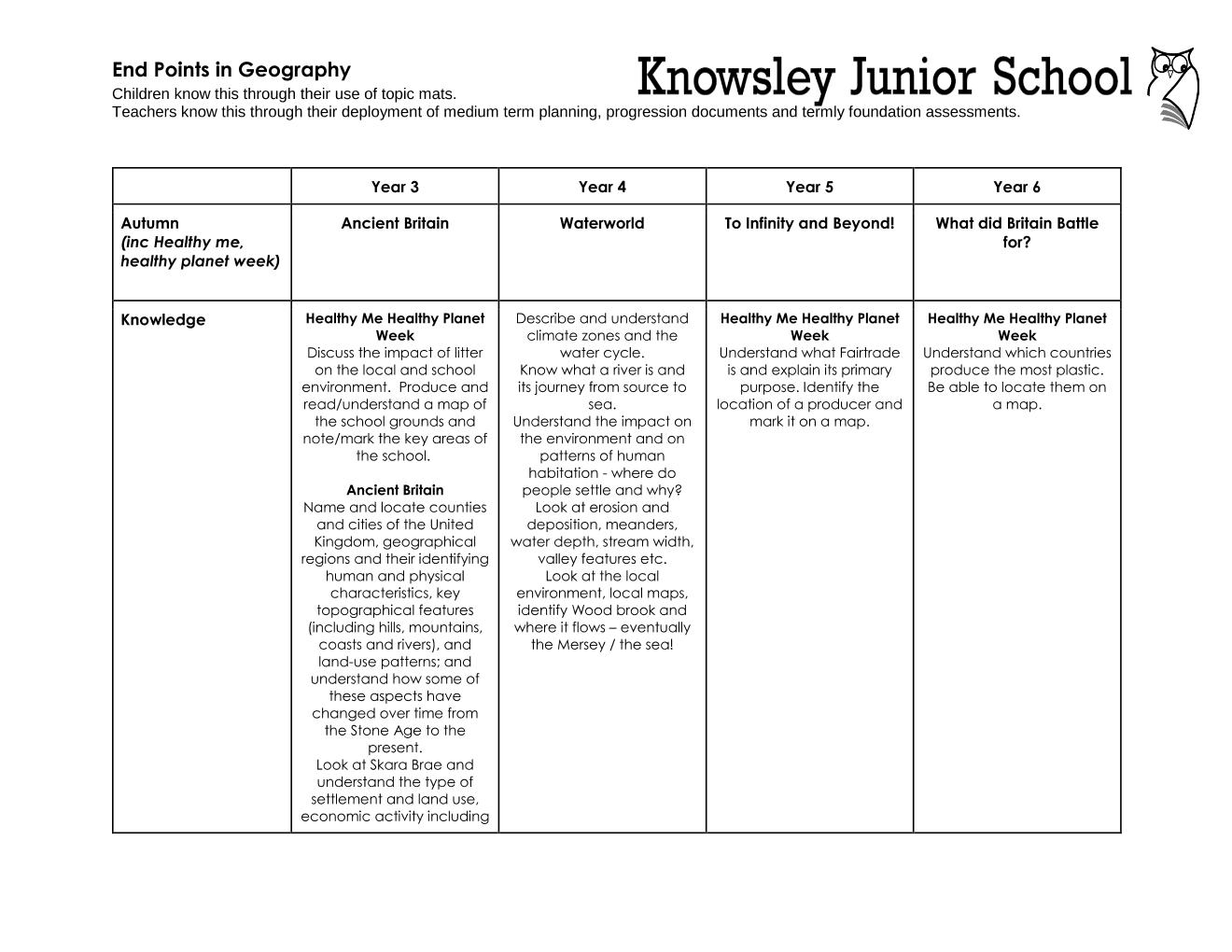
Year 3 begin by locating the counties of Great Britain and discovering where evidence of Ancient Britain was found. Children also locate Stonehenge, discuss how it may have been built and identify how the changes in use of natural resources affected the development of ancient Britain.
During our Victorian Week, Year 3 look focus on their local environment and identify how their own locality has changed over time using historical and modern maps.
In the spring term, children move on to discover what life was like in Ancient Greece, gaining an understanding of Greece’s geography and consider its position and resulting influence over surrounding areas.
During the summer term, year 3 take a greater look at the natural world in the topic of "what is under our feet?" Children learn about the structure of the Earth, where and why volcanoes form, how soil and fossils are made and how the three types of rocks are formed during the rock cycle.
Year 4 begin with the topic of Waterworld where they look at the importance of the water cycle and the impact of rainfall on the environment. Children also look at different methods of irrigation, the significance of cliff erosion and the distinctive features of river systems. Children use their gained understanding to then look at culturally significant rivers from across the globe and also identify the human impact on coral reef systems.
During our Victorian Week, Year 4 look at the changing land use from Victorian times to now using a variety of historical and modern maps.
In the spring term, children begin the topic of Invaders and Settlers and use maps of Britain to identify where it was invaded and where the invaders originated from. Children focus their attention on the expanding Roman Empire and identify the reasons for its expansion and how Rome benefited from it, such as natural resource acquisition. Children move on to investigate what is located in the Castleshaw Valley and discover what still remains from the Roman fort. As the children progress through the timeline of Britain's invaders, children learn more about the Anglo Saxons and Vikings, where they came from, where they settled and why they settled in Britain
In the summer term, Children begin the topic of To Russia with Love using maps to locate Russia and identify its physical and human features. Children then investigate the climate of Russia and also compare and contrast the key localities of Moscow and Manchester.
During our Victorian Week, Year 5 conduct a local study on the changing use of building materials from the Victorian period to modern-day. Children use maps to walk around the local area to identify evidence of these changes in materials.
In the spring term, children locate the earliest civilisations and identify the key physical features which led to each civilisation establishing themselves in their chosen locality. Children look at the river Nile in depth to understand the importance of its physical features to the ancient Egyptians and how they used the river to build and strengthen their civilisation. The valley of the kings and pyramids are then identified and located using maps to understand the significance of their construction and why they were built in that location.
In the summer term, children begin the topic of USA by identifying the continent of North America and its countries, before focusing on the 50 states of the USA. Children research the many different tribes of the Native Americans, where they were located, how they lived and how they used the various natural resources around them. The climate and physical features of the USA are also looked at and researched which is then compared with that of the UK.
During our Victorian Week, Year 6 look at the growth of industry in Oldham throughout the Victorian era and compare to present day.
In the Spring, children locate where the Maya established their civilisation and identify the key human and physical features of South America. They identify factors for population change, investigate the impact of human geography on the region of South America and identify similarities and differences in geography between Brazil and the UK.
Much of the child’s learning is displayed in topic books, where work is produced to a very high standard and where teachers are able to advance literacy and mathematical skills alongside the teaching of geography.
Throughout topics, pupils are taught locational knowledge, place knowledge, human and physical geography and geographical skills and fieldwork and are often challenged further on their geographical understanding helping them to grow as a geographer either during or after their lessons.

|
Geography Skills & Knowledge in Year 3 | [pdf 155KB] |

|
|
|
Geography Skills & Knowledge in Year 4 | [pdf 157KB] |
|
|
|
Geography Skills & Knowledge in Year 5 | [pdf 155KB] |
|
|
|
Geography Skills & Knowledge in Year 6 | [pdf 153KB] |
|
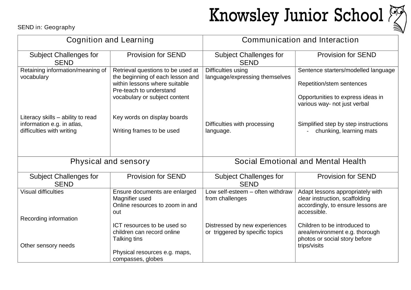
Special Educational Needs and Disabilities: Geography
Please select the document below.
Impact
Geography is assessed every term using the foundation assessment proforma which identifies those working at age related expectations, those exceeding expectations and those working below. It also informs next steps for teachers should an area of weakness/concern be identified.
Progress measures in geography are about the ability to consolidate the fundamental attributes of being a geographer. In addition to that, it assesses deepening learning and understanding of the interaction between physical and human processes, as well as becoming increasingly confident utilising geographical skills, using a variety of resources such as: maps, atlases, globes and digital computer mapping.
As children move through each year group their outcomes will increase in complexity and level of challenge and they will become more confident measuring, recording and presenting data in a variety of ways that are able to be explained with ease. Children at Knowsley Junior School will use an increasing range of geographical vocabulary throughout each year group and this will be evident in their topic work.
How we know that progress is being made?
- Each term, teachers report on attainment of all children, using statements from the Primary Geography Curriculum. This is shared, analysed and queried by the subject lead, to ensure children are making progress.
- Topic books are regularly scrutinised by the leadership team and the subject lead to ensure progress is evident.
- Progress through school will be evident in lesson observations and the complexity of the learning will increase for each year group.
- High achievers are recognised and are tracked to promote continued exceeding progress.

Geography National Curriculum
 |
The National Curriculum KS2 Geography Programme |

Geography Learning Resources
|
Geography Learning Resources |